Climate Impact Chains (CICs) represent an innovative approach to understanding and addressing the multifaceted impacts of climate change on urban environments. Developed to visualize and deconstruct the pathways through which climate hazards affect urban infrastructure, communities, and ecosystems, CICs are increasingly recognized as valuable tools for building urban resilience.
Understanding Climate Impact Chains
Climate Impact Chains (CICs) bring clarity to complex climate challenges. This practical approach grew from climate risk assessment methods, building on research from the Intergovernmental Panel on Climate Change (IPCC) and organizations like GIZ and EURAC. At its core, it’s about breaking down climate risks into clear, manageable pieces that cities can understand and tackle head-on.

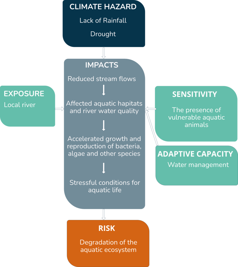
At its core, a Climate Impact Chain is a structured sequence linking climate hazards to potential impacts on society, the economy, and the environment. It begins by identifying a climate-related hazard (e.g., extreme heat, flooding) and follows the sequence of effects it may trigger within a specific urban context. CICs then break down these impacts based on four core components These components include:
- Hazard: The initial climate event or trend that poses a risk. Hazards can be acute events (e.g., hurricanes) or slow-onset changes (e.g., rising temperatures).
- Exposure: The elements within an urban area (e.g., buildings, populations, infrastructure) that are likely to encounter the hazard.
- Sensitivity: The degree to which exposed elements are likely to be affected by the hazard. Sensitivity can vary based on factors like age, condition, or social vulnerability.
- Adaptive Capacity: The capacity of a community, system, or infrastructure to cope with, recover from, or adapt to the impact of the hazard.

How CICs Work
The process of developing a CIC typically begins by identifying a specific climate hazard and mapping its potential impacts across various urban systems. This analysis includes examining the infrastructure that might be affected, the populations most at risk, and the socio-economic factors that could exacerbate or mitigate the hazard’s impact. By establishing these connections, CICs allow cities to see not only the direct effects of a hazard but also the cascading impacts that could disrupt multiple facets of urban life.
CTAPP – An App to vizualize CICs
Climate Resilience App (CTAPP) is an innovative application designed for cities, municipalities and regions that facilitates effective description and monitoring of the impacts of climate change on the territory. The tool provides key data needed for strategic decision-making. At ASITIS we currently have an international feasibility study underway for the CTAPP project in cooperation with ESA. If you are interested, you can learn more about our cooperation with ESA and CTAPP here.
Why Climate Impact Chains Matter for Urban Resilience
Urban areas are particularly vulnerable to climate change due to their high concentration of people, assets, and infrastructure. CICs offer a methodology for cities to build resilience in the face of these challenges.
Cities Face Unique Climate Risks
Think of cities as intricate networks where one climate event can trigger multiple problems.
A single flood can:
and destroy critical infrastructure
Disrupt supply chains and delay emergency response times
Limit access to hospitals and emergency care
Increase waterborne diseases and cause mental health strain

Why Climate Impact Chains Work
CICs allow cities to move from reactive to proactive planning by mapping out how one climate hazard can create a chain of effects.
Example: Tackling heatwaves through:
- Strategic green spaces
- Better healthcare preparation
- Smarter building design
Using CICs as Tools for Systemic Analysis and Bridging Data Gaps

One of the strengths of CICs is their ability to spotlight missing data cities need. By pinpointing what data is missing—such as accurate population exposure data or real-time climate monitoring—CICs help cities prioritize data collection efforts and refine their resilience planning.
Implementing CICs in Cities – Lessons from the VALORADA Project
The success of CICs in urban resilience planning depends on a well-organized implementation process. VALORADA (Validated Local Risk Actionable Data for Adaptation), a HORIZON EUROPE project, tackles these needs. Its goal is to empower European regions and cities to steer the upcoming societal transformation towards sustainable and climate-resilient development.
Cities can follow these steps to integrate CICs into their climate adaptation strategies.
Through workshops and consultations, VALORADA has shown that successful CIC implementation relies on:
- Collaborative partnerships: Engaging local partners, stakeholders, and international experts to share knowledge and coordinate adaptation efforts.
- Tailoring indicators to local contexts: Not all indicators are universally applicable. Each city benefits from selecting and customizing indicators that reflect its unique climate risks and community needs.
- Data-driven decision making: CICs depend heavily on reliable data. VALORADA has emphasized the importance of data management systems that allow cities to collect, analyze, and apply data to their resilience planning effectively.
Conclusion
In a rapidly changing climate, urban areas must adopt comprehensive tools like Climate Impact Chains to anticipate and address climate-related challenges. By enabling cities to understand and visualize complex climate impacts, CICs facilitate proactive adaptation planning. Projects like, CTAPP or VALORADA highlight the importance of data, collaboration, and context-specific strategies, ensuring that CICs are not just theoretical frameworks but practical, actionable solutions for urban resilience.


