


Climate Resilience App
Strengthening urban resilience to climate change through the CICs (Climate Impact Chains) methodology, which analyses and models the cascading effects of climate events in the urban environment.
I am interested in the Climate Resilience App
- Helping cities
comprehensively describe and understand the consequences of climate phenomena
I want to know moreData from satellite imagery, city data and detailed mapped climate change chains allow us to deliver a service that helps cities and municipalities understand the consequences of climate change in detail.

What the Climate Resilience App can offer you
Climate Resilience App is an innovative application designed for cities, municipalities and regions that facilitates effective description and monitoring of the impacts of climate change on the territory. The tool provides key data and analytical tools needed for strategic decision-making and development to increase the resilience of communities and ecosystems to changing climate conditions.


The Climate Resilience App is suitable for:
Representatives of large cities, districts and agglomerations
100 000 and more citisens
Smaller cities
5 000 - 100 000 inhabitants
Environmental consultants
Investment project supply chain teams
Benefits of the Climate Resilience App
The Climate Resilience APP enhances climate resilience by providing municipalities with tools for comprehensive climate impact assessments, strategic goal definition, and progress monitoring. It integrates diverse data sets into an accessible web interface, facilitating evidence-based decision-making. CTAPP supports user management, processes contextualized data, and offers advanced visualization, ultimately empowering cities to plan and implement effective climate adaptation strategies, improving economic and social outcomes

Turn climate data into strategic decisions
Strategic data integration
Climate Resilience App efficiently processes and integrates a wide range of datasets, including satellite, climate and meteorological data. This application provides tools for downloading, delivering and processing information that is accessible and usable for local decision making. It thus enables users to better understand climate threats and vulnerabilities in their areas and to effectively plan adaptation and mitigation strategies.
Choose the right climate impact chain for effective adaptation in your region
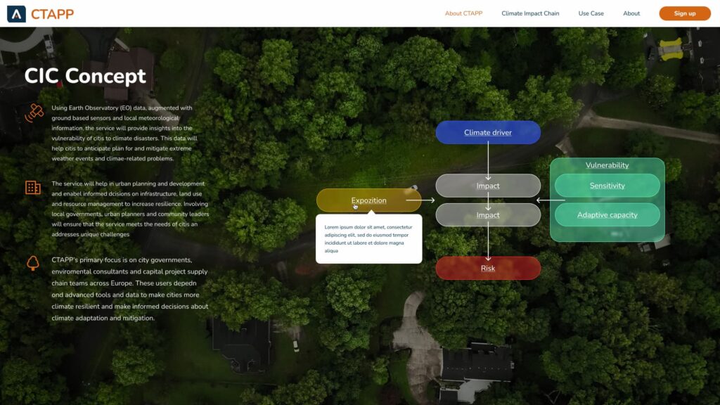
CICs - Climate Impact Chains
The Climate Resilience App provides users with a set of pre-defined climate impact chains (CICs) that serve as the analytical basis for assessing vulnerability to climate change. Users are able to select from these chains those that are most relevant to the specifics of their region or area. This functionality allows cities, municipalities and regions to systematically analyse and model the cascading effects of climate events and their impacts on infrastructure, populations and economic activities. The selection of relevant CICs increases the effectiveness of adaptation planning and interventions that directly target the most pressing threats and needs of a given area.

Harness the power of local data
Local data integration
Climate Resilience App allows users not only to access a wide range of global climate data, but also to integrate local data, which crucially increases the accuracy and relevance of information for specific local conditions. The application supports the uploading of data from local weather stations, sensors and other sources to enable detailed monitoring and analysis of climatic conditions directly in a given area. This feature enhances the effectiveness of planning and adaptation strategies by ensuring that decisions are based on the most up-to-date and accurate data available for a given location.
Measure, assess and improve your climate resilience efficiently
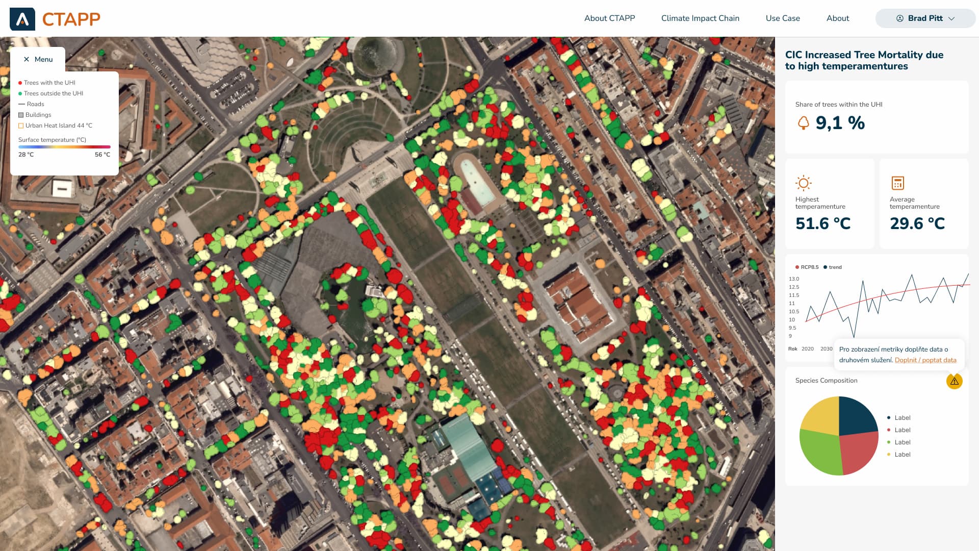
Impact assessment
The Climate Resilience App not only enables the identification and analysis of climate risks, but also provides tools for a comprehensive assessment of the impacts of climate change. The integration of large-scale datasets and climate impact modelling allows users to evaluate the effectiveness of adaptation and plan further action based on concrete results. This approach improves the ability of cities and regions to respond to changing climate conditions, optimise resource use and increase the overall resilience of communities to climate threats.

Climate data integration
Climate Resilience App provides access to a wide range of climate data and predictions, allowing cities and municipalities to better understand potential risks and adapt their planning and development strategies to align with predicted climate change.
Selection of relevant CICs
The application provides tools for selecting and analysing Climate Impact Chains (CICs) that are relevant to a given area. This allows users to identify and focus on the most significant climate threats and vulnerabilities.
Customisation using local data
Climate Resilience App offers advanced capabilities for local data integration and processing, allowing users to tailor models and predictions to actual site conditions. This increases data relevance and accuracy, which is key for effective planning and evidence-based decision making.
Strategic planning and decision-making
The app offers analytical tools for assessing and prioritizing adaptation measures, allowing users to better navigate the complexities of climate change and allocate resources more effectively.


The Climate Resilience App and our cooperation with ESA
An international feasibility study is underway for the RVA Solutions project in cooperation with ESA, focusing on the integration of advanced technologies for urban needs.
ESA project site
Feel free to contact me. I'm here for you.

Ing. Jiří Jedlička, Ph. D.
Write or call us, we will gladly answer your questions.


Kdo tuto službu využil


Martin Vokřál
jednatel společnost ASITIS
We are ready to work together.
Contact us and we will be happy to help you with any of our services
Martin Vokřál
CEO


